Praktische Informationen und FAQ
Der Abschnitt „Praktische Informationen und FAQ“ soll allgemeine Informationen zu EuroVelo liefern und erläutern, wie die Qualität der Routen auf der Website dargestellt wird.
Inhaltsverzeichnis
- Einführung und Definitionen
- Kategorien der EuroVelo-Routen
- Folgen Sie den EuroVelo-Schildern!
- Häufig gestellte Fragen (FAQs)
Einführung & Definitionen
EuroVelo: Vision, Mission und Strategie für 2030
EuroVelo ist das europäische Netz von Fernradwegen, die den gesamten Kontinent durchqueren und verbinden. Der Ausbau von EuroVelo wird zu einer sicheren, direkten, schlüssigen und vernetzten Fahrradinfrastruktur sowie zu Radwegenetzen führen, von denen alle Gruppen von Radfahrern profitieren werden.
Das EuroVelo-Netzwerk wird von der European Cyclists’ Federation (ECF), der weltweit größten Radfahrorganisation, als eine ihrer Kernmarken und -aktivitäten entwickelt und koordiniert. EuroVelo ist eine eingetragene Marke der ECF, und nur von der ECF genehmigte Routen dürfen als EuroVelo bezeichnet werden. Der Ausbau und Betrieb der EuroVelo-Routen erfolgt durch nationale, regionale und lokale Behörden, kommerzielle Dienstleister und Nichtregierungsorganisationen. Erfahren Sie hier mehr.
Unsere Vision für EuroVelo ist ein vollständig ausgebautes und hochwertiges europäisches Radwegenetz, das gut an nationale, regionale und lokale Radwegenetze sowie an andere nachhaltige Verkehrsmittel angebunden ist und zu einer weiteren Zunahme des Alltagsradfahrens und des Radtourismus beiträgt – ganz im Sinne der Vision der ECF, das Radfahren in ganz Europa zu verbessern und zu fördern.
Unsere Mission ist es, den weiteren Ausbau eines nachhaltigen, starken und gut vernetzten europäischen Radwegenetzes zu fördern, das:
- als Impulsgeber für die Steigerung des Radverkehrs fungiert;
- Veränderungen in der europäischen und nationalen Politik und Praxis vorantreibt;
- allen Gruppen von Radfahrern zugutekommt, darunter Alltagsradler, Radtouristen und Freizeitradler;
- nachhaltigen Tourismus fördert.
In den nächsten zehn Jahren wird der Schwerpunkt der Entwicklung des EuroVelo-Netzes auf der Qualitätsverbesserung liegen, nicht auf der Verlängerung des Netzes. Auf den interaktiven Karten auf der Website und im EuroVelo-Routenplaner können Sie die aktuellen Bedingungen einsehen, mit denen Sie unterwegs voraussichtlich konfrontiert sein werden. Eine jährliche Zusammenfassung finden Sie außerdem im „EuroVelo-Bericht zum Stand der Routenentwicklung“, der im Data Hub verfügbar ist.
Nationale EuroVelo-Koordinierungszentren (NECCs)
Die Nationalen EuroVelo-Koordinierungszentren (NECCs) bilden das Bindeglied zwischen der europäischen und der nationalen Ebene der EuroVelo-Routen. In den meisten Fällen handelt es sich um ein Konsortium aus mehreren nationalen Akteuren – darunter häufig Entscheidungsgremien aus den Bereichen Verkehr und Tourismus. Die NECCs und verschiedene andere Akteure sind in ihren jeweiligen Ländern für die EuroVelo-Routen zuständig und kümmern sich um deren Umsetzung, Koordination, Qualitätssicherung und Kommunikation.
Die EuroVelo-Koordination auf europäischer Ebene erfolgt nach dem Subsidiaritätsprinzip. Bei Fragen zur Infrastruktur auf den EuroVelo-Routen wenden Sie sich am besten immer an das NECC des jeweiligen Landes und informieren Sie sich regelmäßig auf dieser Website über den aktuellen Stand entlang der einzelnen Routen. Die Kontaktdaten finden Sie unterhalb der Karte auf dieser Seite.
In einigen Ländern, in denen noch keine Konsortien bestehen, sind die wichtigsten EuroVelo-Partner die Nationalen EuroVelo-Koordinatoren (NEC), die jeweils einen einzelnen Akteur im Land vertreten.
Kategorien der EuroVelo-Routen
Das EuroVelo-Netz ist über 90.000 km lang und umfasst 17 Routen mit einer Länge von mindestens 1.000 km. Die ECF arbeitet gemeinsam mit ihren nationalen EuroVelo-Koordinationszentren und -Koordinatoren (NECCs) kontinuierlich am Ausbau des Netzes, doch es bestehen nach wie vor erhebliche Unterschiede hinsichtlich der Bedingungen auf den Routen (auch zwischen verschiedenen Abschnitten derselben Route). Zwar ist dies bei einem Netzwerk dieser Größe unvermeidlich, doch ist es wichtig, potenziellen Nutzern zu vermitteln, was sie erwarten können, wenn sie einen bestimmten Abschnitt einer Route mit dem Fahrrad befahren. Aus diesem Grund hat die ECF mehrere „Streckenkategorien“ entwickelt, die für das gesamte Netzwerk gelten und auf europäischer Ebene kommuniziert werden (auf dieser Website und auf der gedruckten EuroVelo-Übersichtskarte).
Ein kurzer Rückblick
Die ersten 12 EuroVelo-Routen wurden bereits 1995 festgelegt, als das Netzwerk noch eher eine Vision als Realität war. Die EuroVelo-Initiative wurde am 21. November 1997 in Logroño, Spanien, offiziell ins Leben gerufen. Die meisten dieser ersten 12 Routen wurden seitdem erheblich ausgebaut, doch einige Abschnitte befinden sich noch in der Planungsphase oder im Aufbau.
Beachten Sie, dass es bei diesem Entwicklungsstand nicht mehr möglich ist, neue Routen oder Erweiterungen bestehender Routen in das Netzwerk aufzunehmen, und dass die EuroVelo-Routen, die erst kürzlich in das Netzwerk aufgenommen wurden (insbesondere EuroVelo 14, 15, 17 und 19), insgesamt gut ausgebaut sind.
Anders als in den Anfängen dürfen neue Routen oder Erweiterungen bestehender Routen nur dann in das Netzwerk aufgenommen werden, wenn ein guter Entwicklungsstand vorliegt. EuroVelo-Routen, die erst kürzlich in das Netzwerk aufgenommen wurden (insbesondere EuroVelo 14, 15, 17 und 19), sind insgesamt gut ausgebaut.
Allgemeine Routenkategorien und Bedeutung der Farben in der Kartenlegende

- Dunkelgrüne Linien kennzeichnen zertifizierte EuroVelo-Routen was bedeutet, dass entweder die gesamte Route oder ein Abschnitt von mindestens 100 km den Prozess gemäß der Methodik des Europäischen Zertifizierungsstandards (ECS) der ECF zur Bewertung der Qualität von Radwegen erfolgreich durchlaufen hat. Dies ist die höchste Qualitätsstufe im EuroVelo-Netz.
- Hellgrüne Linien kennzeichnen ausgebaute Routen mit EuroVelo-Beschilderung. Sie bezeichnen Abschnitte mit allgemein guten Radfahrbedingungen, darunter Durchgängigkeit, geringer motorisierter Verkehr und befahrbare Oberflächen, die mit EuroVelo-Schildern ausgeschildert sind. In der Praxis können „ausgebaute Routen“ verschiedene Arten von Infrastruktur bedeuten: getrennte Radwege, Grüngürtel, aber auch Landstraßen mit wenig motorisiertem Verkehr, Stadtstraßen mit aufgemalten Radstreifen oder Radstraßen.
- Hellgrüne Linien kennzeichnen ausgebaute Routen ohne EuroVelo-Beschilderung. Wie oben beschrieben, jedoch ohne Beschilderung.
- Gelbe gestrichelte Linien kennzeichnen 'teilweise ausgebaute Routen mit EuroVelo-Beschilderung. Dazu gehören Straßen mit hohem motorisiertem Verkehrsaufkommen ohne eigene Fahrradinfrastruktur sowie Schotterwege in Wäldern mit unebenem Belag.
- Gestreifte orangefarbene Linien kennzeichnen teilweise ausgebaute Routen ohne EuroVelo-Beschilderung. Wie oben beschrieben, jedoch ohne Beschilderung.
- Gestreifte graue Linien kennzeichnen nicht ausgebaute Routen oder unbekannte Zustände.
- Schließlich zeigen dünne schwarze Linien die Anbindungen an den öffentlichen Nahverkehr. Diese Abschnitte stellen noch nicht ausgebaute Teile des Netzes dar, die Sie umgehen können, indem Sie Ihr Fahrrad in Zug, Bus oder Fähre mitnehmen, um Ihre Reise auf besser ausgebauten Routen fortzusetzen.
Als Radfahrer, der unsere Website besucht, können Sie nach den Streckenabschnitten in den Kategorien suchen, die Ihren Bedürfnissen am besten entsprechen:
- 👨👩👧 Für alle einschließlich Anfänger und Familien: Wenn Sie stark befahrene Straßen und schlechte Straßenbeläge möglichst vermeiden möchten (Abschnitte mit geringerer Qualität können dennoch vorkommen) oder wenn Sie mit Kindern unterwegs sind oder ein nicht standardmäßiges Fahrrad nutzen, sind die EuroVelo-zertifizierten Routen (dunkelgrün auf der Karte) die beste Wahl – schauen Sie sich diese also unbedingt an! Im Jahr 2026 gehören dazu die EuroVelo 1 – Atlantikküstenroute in Frankreich (auch „La Vélodyssée“ genannt) und die EuroVelo 15 – Rhein-Radroute von Breil/Brigels (Schweiz) nach Bad Honnef (Deutschland)
- 🚴 Für die meisten Radfahrer: Wenn du nach allgemein verkehrsarmen Routen mit gutem Belag suchst und kurze Abschnitte (bis zu 5 %) mit weniger idealen Bedingungen bewältigen kannst, wähle ausgebaute Routen (hellgrün auf der Karte). Entscheide dich für ausgeschilderte Routen (leuchtend grün auf der Karte), wenn du lieber Wegweisern folgst, anstatt dich auf dein Smartphone oder deinen Fahrradcomputer zu verlassen.
- 🛣️ Für erfahrene Radfahrer: Wenn Sie mit höherem Verkehrsaufkommen oder unebenerem Untergrund (aber nicht beidem gleichzeitig) gut zurechtkommen, solange diese Sie zu atemberaubenden Landschaften und einzigartigen Erlebnissen führen, könnten teilweise ausgebaute Routen (orange gestrichelt auf der Karte) das Richtige für Sie sein. Beschilderte Abschnitte (gelb gestrichelt auf der Karte) stehen ebenfalls zur Verfügung, wenn Sie gerne Wegweisern folgen.
- 🧭 Für abenteuerlustige Radfahrer: Wenn Sie gerne Regionen erkunden möchten, in denen sich der Radtourismus noch in der Entwicklung befindet, könnten Sie wenig erschlossene/unbekannte Routen (auf der Karte grau gestrichelt) in Betracht ziehen. Diese bieten die besten verfügbaren Routen in diesen Regionen, allerdings können die Bedingungen variieren. Das Abenteuer ist Teil der Reise!
Die für jeden Abschnitt des Netzes ausgewählte Kategorie zum Entwicklungsstand basiert auf Informationen der NECCs und wird jährlich aktualisiert, um den neuesten Stand bei der Realisierung der Routen und der EuroVelo-Beschilderung im gesamten Netz widerzuspiegeln. Dieser Fortschritt wird einmal jährlich im Bericht zum Entwicklungsstand der EuroVelo-Routen zusammengefasst, dessen aktuellste Version vom EuroVelo Data Hub heruntergeladen werden kann.
Obwohl die ECF und die nationalen EuroVelo-Koordinierungszentren (NECC) alle Anstrengungen unternehmen, um sicherzustellen, dass die Strecken und ihr Entwicklungsstand aktuell und korrekt sind, können Fehler oder veraltete Informationen auftreten.
Es ist wichtig zu beachten, dass eine Route, um in das EuroVelo-Netz aufgenommen zu werden, nicht zwangsläufig nach dem European Certification Standard (ECS) der ECF zertifiziert sein muss – einer von der ECF entwickelten Methodik zur Bewertung der Qualität von Radwegen und zur Festlegung von Mindestqualitätskriterien, die eine Route erfüllen sollte. Zukünftige EuroVelo-Strecken, die dem EuroVelo-Netzwerk beitreten, müssen jedoch nach der ECS-Methodik vermessen worden sein und 90 % der wesentlichen ECS-Kriterien erfüllen – das heißt, sie müssen vor Ort überprüft worden sein und alle relevanten Kriterien erfüllen, um für normale Radtouristen geeignet zu sein.
Folgen Sie den EuroVelo-Schildern!
Seit 2026 sind über 53.300 km Strecken in 26 Ländern mit EuroVelo-Schildern ausgestattet, was 58 % des Netzes entspricht. Dazu gehören: Österreich, Belgien, Kroatien, Tschechien, Dänemark, Estland, Finnland, Frankreich, Deutschland, Griechenland, Ungarn, Italien, Lettland, Liechtenstein, Luxemburg, Norwegen, Polen, Portugal, Irland, Serbien, die Slowakei, Slowenien, Spanien, die Schweiz, die Niederlande und die Türkei.
Nachfolgend finden Sie einige Beispiele für EuroVelo-Schilder:

-
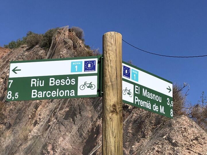
Barcelona and the Sea 7.jpg -
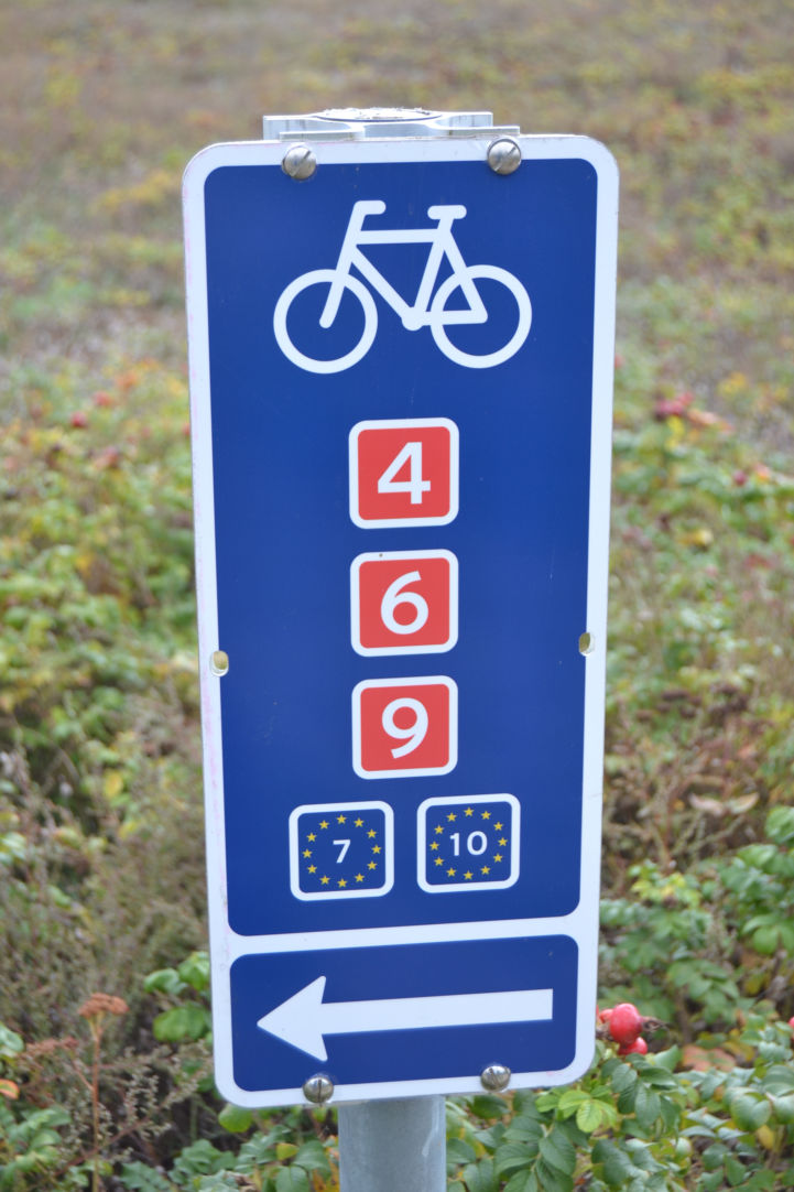
New signage along EuroVelo 7 and EuroVelo 10 south of Copenhagen


Häufig gestellte Fragen
Wo kann ich herausfinden, welche Abschnitte des Netzes bereits fertiggestellt sind?
In vielen Fällen sind wesentliche Abschnitte der EuroVelo-Routen bereits fertiggestellt und ausgeschildert, doch es bestehen nach wie vor Lücken in der hochwertigen Infrastruktur. Wenn Sie sich auf einer EuroVelo-Routenseite befinden, klicken Sie auf eine Etappe (links oder auf der Karte) oder auf ein Land (rechts neben der Karte), um detaillierte Informationen zur Route aufzurufen. Auf den Etappen- bzw. Länderseiten bietet die interaktive Karte einen farbcodierten Überblick über den Streckenverlauf (die Bedeutung der einzelnen Farben finden Sie weiter oben).
Wo kann ich GPS-Tracks des EuroVelo-Netzwerks herunterladen?
Die GPX-Download-Funktion ist verfügbar auf EuroVelo.com! Bitte beachten Sie beim Herunterladen von EuroVelo-GPX-Tracks, dass Sie den Haftungsausschluss lesen müssen, der auch eine Beschreibung des Entwicklungsstands enthält.
Außerdem finden Sie beim Durchstöbern der EuroVelo-Routenseiten viele Links zu nationalen oder regionalen Websites, die von den NECCs verwaltet werden und oft ebenfalls GPS-Tracks zum Herunterladen bereitstellen. Bitte beachten Sie jedoch, dass die ECF auch hierfür keine Verantwortung übernimmt.
Wo finde ich Karten und Reiseführer?
Sie können die gedruckte Karte des gesamten EuroVelo-Netzwerks sowie die Servicehandbücher zu EuroVelo 15 – Rhein-Radroute und EuroVelo 8 – Mittelmeerroute anfordern, indem Sie eine Spende an EuroVelo tätigen.
Eine Liste mit „Karten & Reiseführern“ finden Sie außerdem, indem Sie auf der jeweiligen EuroVelo-Routenseite auf den entsprechenden Reiter klicken.
Karten zu nationalen oder regionalen Abschnitten der EuroVelo-Routen sind derzeit über zahlreiche Online-Quellen erhältlich, darunter:
- France Vélo Tourisme: für Radwege in Frankreich
- Le Routard: hauptsächlich in Frankreich und Belgien
- Bikeline-Radroutenführer: hauptsächlich für Radrouten in Deutschland
- Sustrans: für Radwege im Vereinigten Königreich
- Cicerone: in ganz Europa
Sie können sich auch an das Nationale EuroVelo-Koordinationszentrum oder den Koordinator in Ihrem Land wenden, um die gedruckte Karte des gesamten EuroVelo-Netzes sowie lokale Radführer anzufordern.
Welches Fahrrad sollte ich für meine Reise wählen?
Generell ‚‘'empfehlen wir Ihnen, für alle Arten von Routen Touren- oder Trekkingräder zu verwenden'‚‘, da selbst fertiggestellte Abschnitte Strecken auf Schotter- oder Feldwegen enthalten können, beispielsweise bei der Durchquerung von Naturschutzgebieten, in denen der Bau asphaltierter Straßen nicht empfohlen wird. Im Allgemeinen sind die EuroVelo-Routen nicht für Rennräder ausgelegt.
Nachfolgend finden Sie Vorschläge für die besten Routen in einigen speziellen Fällen.
Ich möchte zum ersten Mal eine Fernradtour auf eigene Faust unternehmen. Welche EuroVelo-Route sollte ich wählen?
Unsere beliebtesten Routen verlaufen entlang der großen europäischen Flüsse – Rhein, Maas, Loire und Donau. Ihre von Natur aus flache Topografie sorgt in Verbindung mit einer erstklassigen Radinfrastruktur für eine sichere und angenehme Fahrt.
Bei den betreffenden Routen handelt es sich um zwei unserer ECS-zertifizierten Routen: EuroVelo 15 – Rheinradweg und EuroVelo 19 – Maasradweg. Ihre ECS-Zertifizierung garantiert hohe Qualität auf fast der gesamten Strecke (wir empfehlen jedoch, den genauen zertifizierten Abschnitt in unserem Routenplaner noch einmal zu überprüfen).
Eine weitere hervorragende Wahl ist EuroVelo 6 – Atlantik - Schwarzes Meer. Auf einer Länge von 4.448 km führt die Route durch 10 Länder und folgt dabei drei der größten Flüsse Europas – der Loire, dem Rhein und der Donau. Dank der lückenlosen Beschilderung zwischen Frankreich und Serbien sowie detaillierter Kartenmaterialien auf der gesamten Strecke ist sie die perfekte Wahl für eine erste Fernradtour.
Ich möchte mehr über die Geschichte Europas erfahren. Welche EuroVelo-Route sollte ich wählen?
Viele EuroVelo-Routen haben einen historischen Bezug – EuroVelo 3 – Pilger-oute und EuroVelo 5 – Via Romea (Francigena) folgen alten Pilgerwegen. Für einen besonders eindringlichen Einblick in die jüngste Geschichte Europas empfehlen wir jedoch die EuroVelo 13 – Iron Curtain Trail, die entlang der Grenze verläuft, die den Kontinent ein halbes Jahrhundert lang in Ost und West teilte.
Ich suche eine sichere Route für eine Reise mit meiner Familie. Welche EuroVelo-Route sollte ich wählen?
Wenn Sie mit kleinen Kindern unterwegs sind, dann ist der französische Abschnitt des EuroVelo 1 – Atlantic Coast Route genau das Richtige für Sie. Dieser Abschnitt der Route ist vollständig nach der EuroVelo-Zertifizierung zertifiziert und bietet 76 % verkehrsfreie Wege, was ihn perfekt für Familienurlaube mit Kindern macht. Sie finden diese Route auch unter dem lokalen Namen La Vélodyssée.
Eine weitere gute Option zum Radfahren mit Kindern ist die EuroVelo 15 – Rhine Cycle Route. Die Route trägt das EuroVelo-Zertifizierungslabel für etwa 60 % ihrer Länge, gemessen an Kontinuität, Streckenkomponenten, Oberfläche und Attraktivität. Sie folgen dem Rhein durch vier Länder von der Quelle bis zur Mündung und genießen dabei eine wunderschöne Landschaft.
Ich würde gerne EuroVelo-Routen mit dem Fahrrad befahren, traue mich aber nicht, die Reise selbst zu planen. Gibt es Anbieter von Radtouren?
Ja! Auf unserer Seite Dienstleistungen für Radfahrer finden Sie auch eine Liste von Radreiseanbietern, die entlang der EuroVelo-Routen tätig sind. Diese Angebote werden von lokalen Reiseveranstaltern konzipiert und organisiert und umfassen vielfältige Touren, die sich je nach Land, Route, Dauer, Preis, Schwierigkeitsgrad, Fahrradtyp, geführter oder individueller Tour sowie Zertifizierungsstatus unterscheiden.
Woher weiß ich, welche Unterkünfte entlang der Routen fahrradfreundlich sind?
Im Bereich Dienstleistungen für Radfahrer auf der EuroVelo-Website findest du eine Liste einiger lokaler, regionaler und nationaler fahrradfreundlicher Angebote entlang der Routen. Sie enthält einen Überblick über 30 fahrradfreundliche Gütesiegel in 24 europäischen Ländern, die solche Siegel vergeben und bestätigen, dass Unterkünfte, Restaurants und andere Betriebe entlang deiner Route bereit sind, dich und dein Fahrrad herzlich willkommen zu heißen! Um dir die Reiseplanung zu erleichtern, haben wir eine interaktive Karte erstellt, mit der du dich durch die fahrradfreundlichen Gütesiegel entlang der EuroVelo-Routen navigieren kannst.
Wer hatte die Idee zu EuroVelo?
Die Idee zu EuroVelo entstand erstmals 1995 bei einem Treffen zwischen dem ECF und seinen britischen und dänischen Partnern (Sustrans und de Frie Fugle). Der ursprüngliche Plan sah die Schaffung von 12 Fernradwegen vor. Seit August 2007 hat die ECF die volle Verantwortung für die Koordination des Projekts übernommen, was zu einer größeren internationalen Anerkennung des Wertes dieser Routen geführt hat. Mehr über die Geschichte von EuroVelo erfahren Sie hier.
Warum gibt es keine EuroVelo-Routen 16 und 18?
Nachdem die EuroVelo 15 – Rheinradweg – in das EuroVelo-Netz aufgenommen wurde, verlaufen die nächsten beiden Routen, die hinzukommen sollen – EuroVelo 17 und EuroVelo 19 – beide auf einer Nord-Süd-Achse durch Europa. Daher wurden ihnen ungerade Nummern zugewiesen, sodass die Nummern 16 und 18 für zukünftige EuroVelo-Routen verfügbar bleiben, die Europa auf einer Ost-West-Achse durchqueren werden. Der Iberische Radweg und der Sava-Radweg sind derzeit Kandidaten für die Aufnahme in das EuroVelo-Netzwerk, jeweils unter den Nummern 16 und 18. Auch die zukünftige EuroVelo 21 wurde für das Jahr 2026 angekündigt. Wenn eine Reihe von Kriterien erfüllt ist, werden diese Routen in Zukunft Teil des europäischen Radwegenetzes werden. Bleibt also auf dem Laufenden!
Ist es möglich, weitere Routen hinzuzufügen?
Ja, wir nehmen im Dreijahresrhythmus Anträge zur Schaffung neuer EuroVelo-Routen oder zur Änderung bestehender Strecken entgegen. Eine ausführliche Erläuterung des Antragsverfahrens für Routen finden Sie hier.
Kann EuroVelo meine Radtour oder meine Spendenradtour für einen guten Zweck sponsern?
Die ECF ist eine gemeinnützige Organisation und kann keine finanziellen Beiträge für Touren leisten, die das EuroVelo-Netzwerk nutzen. Wir freuen uns jedoch sehr über Berichte von inspirierenden Reisen und können diese Geschichten über unsere Social-Media-Kanäle in der gesamten Radsport-Community verbreiten. Außerdem veröffentlichen wir regelmäßig Reiseberichte über Radtouren entlang der EuroVelo-Routen auf EuroVelo.com. Wenn Sie möchten, dass Ihre Geschichte auf der EuroVelo-Website und in den sozialen Medien vorgestellt wird, schreiben Sie uns eine E-Mail an eurovelo@ecf.com.
Wo kann ich Erfahrungsberichte von Leuten lesen, die die Routen mit dem Fahrrad zurückgelegt haben, oder mich inspirieren lassen?
Im Internet gibt es eine riesige Auswahl an Blogs von Radfahrern, die die EuroVelo-Routen befahren haben. Es empfiehlt sich, unter dem Hashtag #EuroVelo auf Instagram, Facebook nachzuschauen, und in unserer Facebook-Diskussionsgruppe was Blogger über ihre Touren berichten. Wir stellen diese Radfahrer außerdem regelmäßig in Artikeln auf EuroVelo.com vor.
Was ist die EuroVelo & Radtourismus-Konferenz?
Die EuroVelo & Radtourismus-Konferenz ist die führende jährliche internationale Konferenz, die über EuroVelo, Radwegenetze und Radtourismus informiert, inspiriert und Kontakte knüpft. Sie bringt alle Akteure der Radtourismusbranche zusammen – Destinationsmanager, Radtourismus-Experten, Universitäten und Wissenschaft, Tourismusverantwortliche, Behörden, Nutzervertreter, Reiseveranstalter, öffentliche Verkehrsunternehmen, Vertreter von Beherbergungsbetrieben und viele weitere. Lesen Sie hier mehr dazu: EuroVelo- und Radtourismus-Konferenzen – EuroVelo für Fachleute.